Kategorien durchsuchen
Entdecken
Fiverr Pro
Deutsch
$
USD
Level 1


Automatische Übersetzung
Ich bin ein Geospatial Engineer (MSc) mit über 15 Jahren Erfahrung in der Erstellung von Digital Elevation Models, Konturkarten, GIS-Lösungen, LiDAR und Vermessung. Ich helfe Ingenieuren, Beratern, Forschern und Landentwicklern dabei, Rohhöhendaten in präzise, entscheidungsfertige Oberflächenmodelle umzuwandeln.
Dieses Gig umfasst:
Zentrale Leistungen
Zusätzliche Dienstleistungen
Ich liefere im Dateiformat und in der Auflösung, die zu deiner Software passt. Sag mir einfach dein Zielprogramm, und ich passe die Dateien entsprechend an.
Verwendete Tools: ArcGIS Pro, QGIS, Google Earth, Global Mapper, Pix4D, Metashape, AutoCAD Civil 3D
Vertraut von wiederkehrenden Kunden weltweit.
Schreib mir deine Datenquelle und Projektgebiet (Adresse, Koordinaten oder Google Maps Pin), und ich bestätige Umfang, Leistungen und Bearbeitungszeit, bevor du bestellst.
GIS Mapping, Drone Surveying, CAD Site Plans, 3D Modeling and Animations
Level 1
Sprachen
Automatische Übersetzung
Automatische Übersetzung
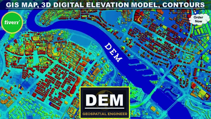
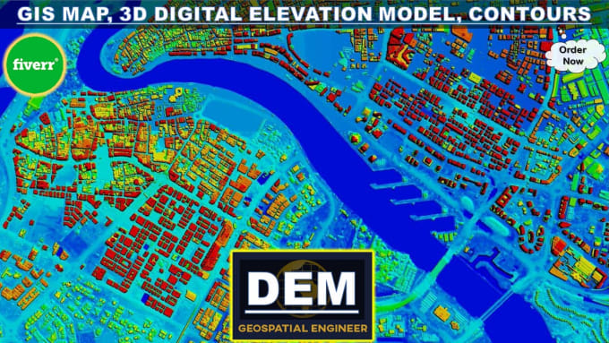
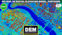
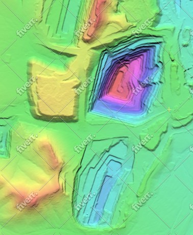
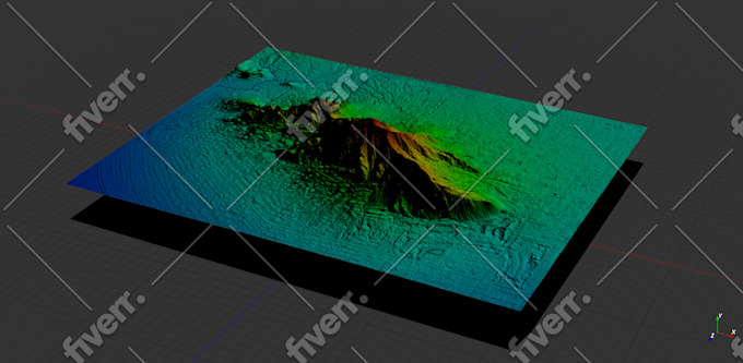
Was ist ein digitales Höhenmodell (DEM)?
Ein digitales Höhenmodell (DEM) ist eine 3D-Computergrafikdarstellung von Höhendaten zur Darstellung des Geländes. DEM ist eine Raster-GIS-Ebene mit Rastergittern der Erdoberfläche in Bezug auf das vertikale Datum (Nullhöhe).
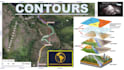
Was sind Höhenlinien und topografische Karten?
Vereinfacht ausgedrückt markieren Höhenlinien Punkte gleicher Höhe auf einer Karte. Topographie ist die Untersuchung geografischer Merkmale einer Landschaft. Eine Karte mit Höhenlinien darauf wird als topografische Karte bezeichnet. Topografische Karten stellen im Wesentlichen die dreidimensionale Landschaft der Erde im zweidimensionalen Raum einer Karte dar.
Welche Daten benötigen Sie zur Erstellung eines DEM und einer Höhenlinienkarte?
Zum Erstellen einer DEM- und Konturkarte benötige ich normalerweise Höhendaten aus Quellen wie Topografien oder Bodenvermessungen (GNSS, DGPS, Totalstation, Laserscanner, LiDAR), photogrammetrische Stereobilder (Satellitenbilder, Luftaufnahmen), SAR, Radar-Datensätze oder topografische Blätter.
Können Sie die Höhenlinienintervalle und Kartenspezifikationen meinen Anforderungen entsprechend anpassen?
Auf jeden Fall! Ich verstehe, dass verschiedene Projekte unterschiedliche Anforderungen haben können. Ob Sie bestimmte Höhenlinienintervalle, Kartenausschnitte, Koordinatensysteme oder andere Spezifikationen benötigen, ich kann die Ergebnisse genau auf Ihre Bedürfnisse zuschneiden.
Welche Arten von Projekten können von Ihren Dienstleistungen profitieren?
Meine Dienste eignen sich ideal für eine breite Palette von Projekten, darunter Landentwicklung, technisches Design, Wassereinzugsgebietsmodellierung, Standortplanung, Klimaanalyse und mehr. Ob Sie ein Ingenieurbüro oder ein Umweltberater sind, ich kann Ihnen bei Ihren GIS-Konturkartierungs- und DEM-Anforderungen helfen.
Was sind erweiterte Einsatzmöglichkeiten digitaler Höhenmodelle?
- Geographische Informationssysteme / GIS-Kartierung - Landvermessung und topografische Konturen - 3D-Visualisierung - Bauingenieurwesen - Hydrologie / Hydrologische Modellierung - Hochwassermodelle und -kartierung - Straßen- / Umwelt- / Wasserressourcentechnik - Telekommunikation und Versorgungswirtschaft
Welche Software verwenden Sie zur Entwicklung von DEMs und Konturkarten?
Ich bin spezialisiert auf die Verwendung von ArcGIS Pro, einer professionellen GIS-Software, zur Entwicklung hochwertiger DEMs und Konturkarten. ArcGIS Pro bietet erweiterte Funktionen für die Geländeanalyse und -visualisierung und gewährleistet genaue und detaillierte Ergebnisse.
Wie lange dauert es normalerweise, bis das Endprodukt geliefert wird?
Die Bearbeitungszeit kann je nach Komplexität und Umfang des Projekts variieren. Nach der Besprechung Ihrer Anforderungen erstelle ich Ihnen einen voraussichtlichen Lieferzeitplan. Seien Sie versichert, dass ich bestrebt bin, qualitativ hochwertige Ergebnisse rechtzeitig zu liefern, damit Sie Ihre Projektfristen einhalten können.
Bieten Sie Überarbeitungen an, wenn ich mit dem ursprünglichen Ergebnis nicht zufrieden bin?
Ja, Kundenzufriedenheit steht für mich an erster Stelle. Ich biete Überarbeitungen an, um sicherzustellen, dass die endgültigen Ergebnisse Ihren Erwartungen und Projektanforderungen entsprechen.
| (15) | ||
| (1) | ||
| (0) | ||
| (0) | ||
| (0) |
bleblanc03

Vereinigte Staaten
Great to work with. Delivered nice assets for my project. I would not hesitate to reach out again if/when I need more work at this level.
400 $-600 $
Preis
3 Wochen
Dauer
jebjeb2000
Vereinigte Staaten
I needed a model of a mountain for architectural rendering. Geospatial provided a highly detailed file that was actually far too large for my program to handle. Geospatial followed up with several options of smaller size, and I was able to use the edits. They were communicative in adjusting the parameters to fit what I needed. Thank you!
100 $-200 $
Preis
2 Wochen
Dauer
Antwort des Freelancers
ricmed372
Wiederkehrender Kunde
Vereinigte Staaten
Thank you. I appreciate the work
100 $-200 $
Preis
5 Tagen
Dauer

jasonwarner845
Wiederkehrender Kunde

Costa Rica
This is my third order with Geospatial. Always high quality, timely, and visually appealing.
Bis zu 50 $
Preis
1 Tag
Dauer
jasonwarner845
Wiederkehrender Kunde
Costa Rica
This is my second project with Geospatial Engr. I found them after an underwhelming experience with another provider. Very pleased with the technical capabilities and professional way they presented the data. When the need arises, I would be happy to work with Geospatial again.
100 $-200 $
Preis
8 Tagen
Dauer
| (15) | ||
| (1) | ||
| (0) | ||
| (0) | ||
| (0) |
bleblanc03
Vereinigte Staaten
Great to work with. Delivered nice assets for my project. I would not hesitate to reach out again if/when I need more work at this level.
400 $-600 $
Preis
3 Wochen
Dauer
jebjeb2000
Vereinigte Staaten
I needed a model of a mountain for architectural rendering. Geospatial provided a highly detailed file that was actually far too large for my program to handle. Geospatial followed up with several options of smaller size, and I was able to use the edits. They were communicative in adjusting the parameters to fit what I needed. Thank you!
100 $-200 $
Preis
2 Wochen
Dauer
Antwort des Freelancers
ricmed372
Wiederkehrender Kunde
Vereinigte Staaten
Thank you. I appreciate the work
100 $-200 $
Preis
5 Tagen
Dauer
jasonwarner845
Wiederkehrender Kunde
Costa Rica
This is my third order with Geospatial. Always high quality, timely, and visually appealing.
Bis zu 50 $
Preis
1 Tag
Dauer
jasonwarner845
Wiederkehrender Kunde
Costa Rica
This is my second project with Geospatial Engr. I found them after an underwhelming experience with another provider. Very pleased with the technical capabilities and professional way they presented the data. When the need arises, I would be happy to work with Geospatial again.
100 $-200 $
Preis
8 Tagen
Dauer