Diese Dienstleistung ist vorübergehend nicht verfügbar
I will do interactive gis mapping in arcgis, qgis, erdas imagine for you


Über diesen Service
PLEASE CONTACT ME BEFORE PLACING ORDER!
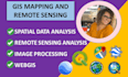
If you are looking for GIS MAPPING and REMOTE SENSING, or any kind of SPATIAL and RASTER ANALYSIS then you are at the right gig.
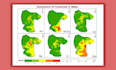
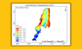
I will make eye-catching and printable digital maps, charts, and reports for your professional use with 100% satisfaction. I will also help you with GIS and Remote Sensing project work, data visualization, and presentation slides.
I will render the best services in:
- Map Digitization
- LULC mapping
- Parcel mapping
- Data Extraction from Google Earth, Google Maps
- Georeferencing
- Terrain Mapping
- Suitability Analysis
- WebGIS
- Heat Maps/Thematic Maps/ Hotspots Maps/ Choropleth maps/ Density Maps
- NDVI, EVI, SAVI, NDWI, and other indices mapping
- Image Classification (Supervised/ Unsupervised), Accuracy Assessment
- Printable Maps
- DEM, Watershed Analysis, Viewshed Analysis, Contour Mapping
Software:
- ArcGIS
- QGIS
- ERDAS
- ENVI
- SNAP
The gig packages provided are merely a general idea. If you want any other service please get in touch with me so that we may talk about it.
How can I be of service to you? Let's have a conversation!
Lerne Zoha Mahmood kennen
GIS and Remote Sensing Expert
- AusPakistan
- Mitglied seitJuni 2021
- Letzte Lieferung3 Jahre
Sprachen
Englisch, Deutsch, Spanisch, Französisch
1 Bewertungen für diesen Service
| (1) | ||
| (0) | ||
| (0) | ||
| (0) | ||
| (0) |
Zusammensetzung der Bewertung
- Kommunikation
- An einen Freund weiterempfehlen
- Dienstleistung wie beschrieben
Sortieren nach:
A arsalan00123
Wiederkehrender Kunde

Vereinigte Staaten
Fast n reliable
Hilfreich?
1 Bewertungen für diesen Service
| (1) | ||
| (0) | ||
| (0) | ||
| (0) | ||
| (0) |
Zusammensetzung der Bewertung
- Kommunikation
- An einen Freund weiterempfehlen
- Dienstleistung wie beschrieben
Sortieren nach:
A arsalan00123
Wiederkehrender Kunde

Vereinigte Staaten
Fast n reliable
Hilfreich?

