Kategorien durchsuchen
Deutsch
$
USD
Verbinden Sie sich mit Ihrer KI

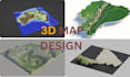

Need to transform real-world elevation data into a 3D terrain map, shaded relief map, or printable STL model?
I can help you turn your location, coordinates, or area of interest into an accurate and visually impressive terrain model based on real topographic and elevation data.
Whether you need a terrain model for 3D printing, GIS visualization, architecture, geography, urban planning, education, landscape design, presentation, research, or a personal project, I can create a result tailored to your specific requirements.
What I can help you with:
My goal is to make the process simple for you while delivering a clean, accurate, detailed, and usable terrain model that matches your intended purpose.
Simply send me the location, coordinates, map area, desired dimensions, and preferred file format, and Ill take care of the rest.
Let's turn your real-world landscape into a professional 3D model.
Bitte informiere den Freelancer über alle Präferenzen oder Bedenken in Bezug auf den Einsatz von KI-Tools bei der Ausführung und/oder Lieferung deines Auftrags.
MAP TOPOGRAPHY DESIGNER
Sprachen


