Kategorien durchsuchen
Entdecken
Fiverr Pro
Deutsch
$
USD
Level 2
Earth Explorer Geologist!
Kompetenzen
Meine Dienstleistungen
Möchtest du auf Stundenbasis arbeiten?
Erzähle Geoscientist, was du brauchst.
35 $
/
StundeNational Engineering Services Pakistan (NESPAK)
Vollzeit • 7 yrs 9 mos
GIS&RS Specialist
May 2022 - Present • 4 yrs 2 mos
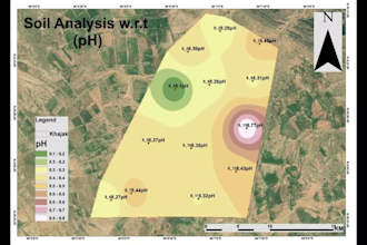
Conducted Electrical Resistivity Surveys (ERS) to assess groundwater quality and subsurface formations. Evaluated soil resistivity, composition, texture, moisture content, and contamination levels for agricultural and infrastructure projects. Prepared Initial Environmental Examination (IEE) reports to identify and mitigate potential environmental impacts. Utilized Google Earth Engine (GEE) for land classification and environmental monitoring. Conducted high-precision drone surveys and topographic mapping for urban planning and agriculture. Integrated remote sensing, GIS, geotechnical assessments, and environmental analysis to support sustainable water resource development. I possess advanced expertise in ArcGIS Pro, ArcGIS Online, ArcGIS, Global Mapper, EnMAP-Box, QGIS, ERDAS IMAGINE, Landscape Master Planning, SketchUp, AUTOCAD 2D, 3D and Dashboard integration.
Enumerator / Land Surveyor
Oct 2018 - May 2022 • 3 yrs 7 mos
Conducted cadastral mapping and land use digitization for Punjab's land record management. Performed site surveys and data collection. Managed data entry and geospatial processing for cadastral mapping.
Assistant Material Engineer
MAAKSONS (PVT) LTD. • Vollzeit
Dec 2017 - Sep 2018 • 9 mos
Conducted daily testing and reporting for construction materials. Performed asphalt, concrete, and soil quality tests. Ensured compliance with engineering standards for construction materials.
| (9) | ||
| (1) | ||
| (0) | ||
| (1) | ||
| (0) |
oliverj09

Großbritannien
Excellent experience! Highly professional, knowledgeable, and detail-oriented. The work was accurate, well-presented, and delivered on time. Great communication throughout. I highly recommend this geoscientist and would gladly work with them again.
Antwort des Freelancers
judylynn44

Vereinigte Staaten
Very pleased that the assignment was completed prior to the due date.
Antwort des Freelancers
crepin_96

Deutschland
chrisfagan13
Wiederkehrender Kunde
Vereinigte Staaten
Rashid Menhas Geoscientist did a wonderful job with this project. I would strongly recommend his work. Thank you!
laurent20
Wiederkehrender Kunde

Ruanda
Impressive understanding of geology, minerals, and GIS techniques. Great experience and highly recommended
