Kategorien durchsuchen
Entdecken
Fiverr Pro
Deutsch
$
USD


Automatische Übersetzung
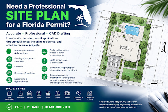
Benötigst du einen professionellen Bebauungsplan für eine Florida-Genehmigung?
Ich erstelle genaue und professionelle CAD-Bebauungspläne für Genehmigungsanträge in ganz Florida, einschließlich Wohn- und kleiner gewerblicher Projekte.
Ich kann aus Grenzvermessungen, topografischen Vermessungen, Plänen, bestehenden Plänen, Skizzen, Grundstücksaufzeichnungen und anderen verfügbaren Daten arbeiten.
WAS ICH ZEIGEN KANN
PROJEKTTYPEN
Neubau, Erweiterungen, Garagen, Schuppen, Pools, Terrassen, Veranden, Zäune, Zufahrten, Parkplätze und Abbruchprojekte.
Ich kann auch verfügbare Grundstücksinformationen recherchieren und Vermessungs-/topografische Daten einbeziehen, einschließlich State Plane Koordinaten, wenn diese bereitgestellt werden.
Bitte informiere den Freelancer über alle Präferenzen oder Bedenken in Bezug auf den Einsatz von KI-Tools bei der Ausführung und/oder Lieferung deines Auftrags.
CAD Drafting Specialist
Sprachen
Automatische Übersetzung
Automatische Übersetzung
Deckt du alle Countys in Florida ab?
Ja. Ich biete CAD-Bebauungsplan-Entwürfe für Grundstücke in ganz Florida an, abhängig von den Projektanforderungen.
Kannst du Grundstücksinformationen für mein Projekt finden?
Ja. Ich kann verfügbare öffentliche Grundstücksinformationen, Pläne, Nutzungsrechte und andere relevante Aufzeichnungen recherchieren. Bitte stelle auch alle Dokumente oder Informationen bereit, die du hast.
Kannst du von einer Vermessung oder topografischen Vermessung arbeiten?
Ja. Ich kann Grenz- und topografische Vermessungsdaten verwenden, um den CAD-Bebauungsplan zu erstellen, einschließlich Vermessungspunkte, Koordinaten und Höhenangaben.
Kannst du mit State Plane Koordinaten arbeiten?
Ja. Ich kann State Plane Vermessungsdaten importieren und verwenden, wenn die entsprechenden Koordinateninformationen bereitgestellt werden.
Was, wenn ich keine Vermessung habe?
Ich kann die verfügbaren Grundstücksinformationen prüfen und feststellen, welche Daten verwendet werden können. Für genaue Grenzen und Abstandsflächen ist möglicherweise eine aktuelle Vermessung erforderlich.
Kannst du meinen Stadt- oder Landkreis-Genehmigungsanforderungen folgen?
Ja. Bitte stelle alle Checklisten, Kommentare, Beispielpläne oder spezifischen Anforderungen deiner Genehmigungsstelle bereit, und ich werde sie bei der Erstellung des Plans berücksichtigen.
Wird der Bebauungsplan von der Stadt oder dem Landkreis genehmigt?
Die Genehmigung kann nicht garantiert werden. Die endgültige Entscheidung liegt bei der örtlichen Genehmigungsbehörde.
Stellst du einen Stempel eines Vermessers, Ingenieurs oder Architekten aus?
Nein. Professionelle Siegel und Stempel sind nicht enthalten. Dieses Gig bietet nur CAD-Entwurf und Erstellung des Bebauungsplans.
