Kategorien durchsuchen
Entdecken
Fiverr Pro
Deutsch
$
USD


Automatische Übersetzung
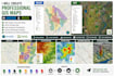
Ich erstelle professionelle GIS-Karten mit ArcGIS und QGIS.
Services:
GIS-Kartierung
Räumliche Analyse
Georeferenzierung
Digitalisierung
Shapefile-Bearbeitung
GeoJSON-Konvertierung
Kartografische Layouts
Karten-Design
Ich kann mit GIS-Daten, Satellitenbildern, CAD-Dateien und Geodatenbanken arbeiten.
Warum mich wählen?
Präzise Arbeit
Schnelle Lieferung
Professionelle Kommunikation
Erfahrung mit GIS und CAD
Bitte kontaktiere mich, bevor du eine große Bestellung aufgibst.
Sprachen
Automatische Übersetzung
Automatische Übersetzung
Welche Dateiformate akzeptieren Sie?
Ich kann mit Shapefile, GeoJSON, KML, KMZ, DWG, DXF, CSV, Excel und Geodatenbank-Dateien arbeiten.
Kannst du Karten in ArcGIS und QGIS erstellen?
Ja. Ich arbeite je nach Projektanforderungen mit ArcGIS, ArcGIS Pro und QGIS.
Kannst du Raum-Analysen durchführen?
Ja. Ich kann räumliche Analysen, Digitalisierung, Georeferenzierung und die Erstellung kartografischer Layouts durchführen.


