Kategorien durchsuchen
Entdecken
Fiverr Pro
Deutsch
$
USD


Automatische Übersetzung
Brauchst du professionelle Drohnenkartierung aus deinen Originalaufnahmen?
Ich verarbeite deine Drohnenaufnahmen zu georeferenzierten Orthomosaiken, Höhenmodellen und 3D-Kartenprodukten für Vermessung, Landwirtschaft, Bauwesen und GIS-Anwendungen.
Dienstleistungen
Fotogrammetrie mit Drohnen und Erstellung von Orthomosaiken
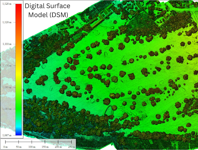
Digital Surface Models (DSM)
Digital Terrain Models (DTM), wo sinnvoll
Dichte Punktwolken und 3D-Rekonstruktion
Konturenkartierung und GIS-freundliche Exporte
Software: DJI Terra, Agisoft Metashape, Pix4D und QGIS, je nach Projektanforderung.
Ausgabedaten: Verfügbare Formate umfassen GeoTIFF, LAS/LAZ und vereinbarte Bild- oder GIS-Formate.
ZUR EINSTEIGUNG, sende mir deine Original-Drohnenaufnahmen, ungefähre Vermessungsfläche, gewünschte Ausgaben und bekanntes Koordinatenreferenzsystem. Gib bitte auch an, ob du RTK/PPK-Daten oder Ground Control Points hast.
Bildqualität, Überschneidung, Gelände und Vermessungskontrollen beeinflussen Verarbeitungsergebnisse und Genauigkeit. DTM-Extraktion und komplexe Projekte können ein individuelles Angebot erfordern.
Bitte kontaktiere mich vor einer großen Datensatzbestellung, um Umfang, Preis und Lieferzeit abzustimmen.
Drone Survey, GIS and Remote Sensing Specialist
Sprachen
Automatische Übersetzung
Automatische Übersetzung
Kannst du Bilder von meiner Drohne verarbeiten?
Ja, vorausgesetzt die Bilder und verfügbaren Kamerainformationen sind mit dem Verarbeitungsablauf kompatibel. Bitte teile, soweit möglich, die Drohne und das Kameramodell mit.
Kannst du ein georeferenziertes Orthomosaik erstellen?
Ja, wenn das Quellmaterial und die vorhandene Positions- oder Steuerinformationen die Georeferenzierung unterstützen. Der Grad der Positionsgenauigkeit hängt von diesen Eingaben ab.
Kannst du ein DTM für die Geländesformung erstellen?
Ich kann die Daten prüfen und feststellen, ob ein nützliches Gelände-Modell generiert werden kann. Bereiche mit dichter Vegetation oder eingeschränkter Bodenblick erfordern möglicherweise zusätzliche Bodendaten oder spezielle Verarbeitung.
Kannst du eine große Vermessung verarbeiten?
Ja, abhängig von Größe, Qualität und Komplexität des Datensatzes. Bitte kontaktiere mich vor der Bestellung eines großen Projekts, damit ich dir ein passendes Angebot und eine Lieferzeit nennen kann.
Bekomme ich bearbeitbare GIS-Dateien?
Vereinbarte Ausgaben können GeoTIFF-Raster, LAS/LAZ-Punktwolken und Vektordateien umfassen, wo zutreffend. Bestätige deine gewünschten Formate vor der Bestellung.