Kategorien durchsuchen
Deutsch
$
USD
Deine KI mit Fiverr verbinden

Automatische Übersetzung
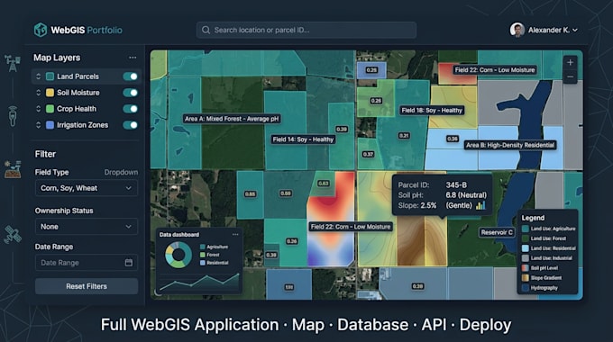
️ Ich baue eine komplette WebGIS-Plattform, nicht nur ein Karten-Widget.
Benötigst du eine interaktive Karte, eine räumliche Datenbank, eine Geodaten-API oder eine komplette GIS-Anwendung? Ich erstelle produktionsreife WebGIS-Lösungen, die auf dein Business zugeschnitten sind.
WAS ICH BIETE:
Interaktive Karten
PostGIS-Raumdatenbank
Geospatiale REST-APIs
Cloud-Deployment
REAL PROJECT EXPERIENCE
TECH STACK: Mapbox, Leaflet, MapLibre, React, Next.js, TypeScript, Angular, Node.js, Go, PostgreSQL, PostGIS, AWS.
WebGIS and Full Stack Developer, Mapbox, PostGIS
Sprachen
Automatische Übersetzung
Automatische Übersetzung
Für welche Branchen baust du WebGIS?
Immobilien, Landwirtschaft, Logistik, Energie, Bauwesen, Regierung und jedes Unternehmen, das mit Standorten arbeitet. Wenn du geografische Daten hast und sie visualisieren oder analysieren möchtest, kann ich helfen.
Kannst du mit vorhandenen Daten (CSV, Shapefile, GeoJSON) arbeiten?
Ja. Ich kann Daten aus CSV, GeoJSON, Shapefile (.shp), KML und den meisten anderen GIS-Formaten nach PostGIS importieren und bereinigen.
Muss ich einen Mapbox API-Schlüssel bereitstellen?
Für Mapbox-basierte Karten benötigst du ein kostenloses Mapbox-Konto. Ich kann dich durch die Einrichtung führen. Alternativ kann ich Leaflet + OpenStreetMap-Tiles verwenden, ganz ohne API-Schlüssel.
Was, wenn mein Projekt größer ist als das Premium-Paket?
Schreibe mir mit deinen Anforderungen. Ich betreue große Enterprise-GIS-Projekte und erstelle dir ein individuelles Angebot
Werde ich der Quellcode besitzen?
Ja, vollständiges Quellcode-Eigentum ist enthalten. Ich liefere über GitHub oder jede Plattform deiner Wahl.