Kategorien durchsuchen
Entdecken
Fiverr Pro
Deutsch
$
USD

Environmental Engineer GIS Specialist
Kompetenzen
Meine Dienstleistungen
Environmental GIS Specialist
Ministry of Environment and Climate Change • Vollzeit
Jan 2022 - Dec 2024 • 2 yrs 11 mos
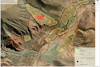
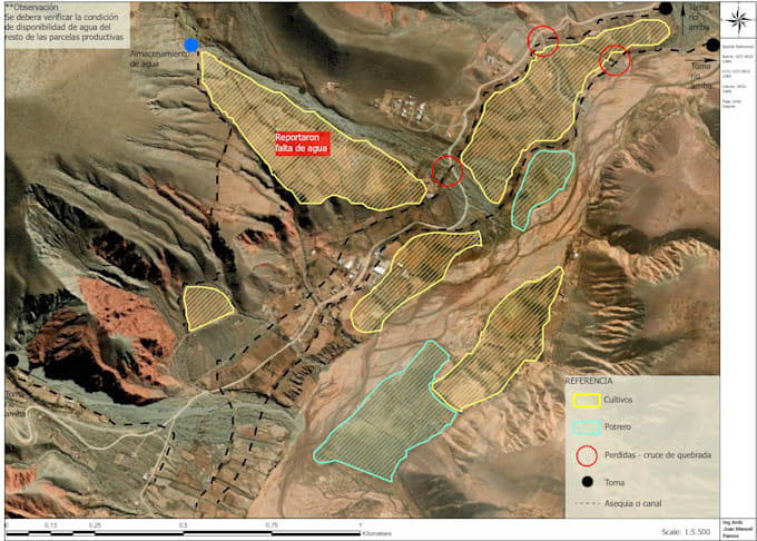
Professional Summary Environmental professional with experience in public and private sectors, focused on environmental management, land-use planning, and sustainability projects. GIS & Technical Skills Advanced GIS technician with experience in environmental diagnostics using satellite and radar imagery. Skilled in topographic and hydrological analysis, map production, waste site surveys, georeferencing, and spatial data analysis to support environmental planning and decision-making. Environmental Experience Worked at the Secretariat of Environment and Climate Change of Jujuy within the Environmental Land-Use Planning Area and the GIRSU Project Implementation Unit. Previous experience in private environmental consulting, including environmental impact assessments, environmental audits, monitoring plans, and waste management training.
| (5) | ||
| (0) | ||
| (0) | ||
| (0) | ||
| (0) |

mochu2020
Wiederkehrender Kunde

Spanien
This is the second project I've done with Juan, and everything went perfectly. He's a great professional, and I hope to work with him again on other projects.
tomdavidson2005
Wiederkehrender Kunde

Vereinigte Staaten
mochu2020
Wiederkehrender Kunde
Spanien
Juan is an excellent professional. Communication was fast and seamless, and he delivered the work ahead of schedule. I’m very happy with the results and look forward to working with him again in the future.
florcastee13

Argentinien
Excelente trabajo y muy buena comunicación. Entendió perfectamente el pedido y entregó exactamente lo que necesitaba, antes de lo esperado. Muy recomendable, volvería a trabajar con él.
rubengareca11
Argentinien
Outstanding quality! The model is highly accurate and the topographic details are perfect. Truly an expert with excellent technical knowledge and professional delivery. Fast turnaround and great communication throughout the process. 10/10 recommended for any GIS project!