Kategorien durchsuchen
Entdecken
Fiverr Pro
Deutsch
$
USD
Level 2


Automatische Übersetzung
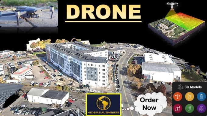
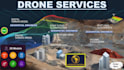
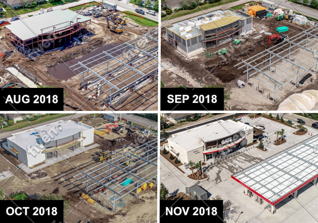
Ich bin ein Experte für Luftbildvermessung, Photogrammetrie, Drohnen-Datenverarbeitung und Kartierung und biete professionelle Dienstleistungen, die auf die Bedürfnisse deines Projekts zugeschnitten sind. Mit fortschrittlicher Drohnentechnologie liefere ich hochqualitative Orthomosaikkarten, detaillierte 3D-Modelle und präzise Punktwolken für Bauwesen, Tiefbau, Immobilien, Landentwicklung, Landwirtschaft und mehr.
Egal, ob du genaue Geländedaten, Volumenanalysen oder visuelle Standortinspektionen brauchst, ich sorge für schnelle Ergebnisse und zuverlässige, georeferenzierte Outputs, die sofort einsatzbereit sind.
Zu meinen Dienstleistungen gehören:
Verwendete Software:
Als Drohnenspezialist behandle ich Photogrammetriedaten von DJI-Drohnen (Matrice, Mavic, Mini, Inspire, Phantom, Air) sowie von festen oder hybriden UAVs wie senseFly eBee und Wingtra mit Fachkenntnis.
Lass uns dein Projekt mit modernster Drohnendaten zum Leben erwecken. Kontaktiere mich, um loszulegen!
VOR DER BESTELLUNG KONTAKTIEREN
+ Hervorragende Bewertung von Fiverr-Kunden.
Bitte informiere den Freelancer über alle Präferenzen oder Bedenken in Bezug auf den Einsatz von KI-Tools bei der Ausführung und/oder Lieferung deines Auftrags.
Pro Experts in GIS, Mapping, 3D Models, Drones, and Civil Engineering
Level 2
Sprachen
Automatische Übersetzung
| (4) | ||
| (0) | ||
| (0) | ||
| (0) | ||
| (0) |
laynesup
Wiederkehrender Kunde

Vereinigte Staaten
Seller was great to work with, much appreciated!
Antwort des Freelancers
laynesup
Wiederkehrender Kunde
Vereinigte Staaten
Seller was great to work with! Looking forward to working with him in the future!
Antwort des Freelancers
raitisupmalis

Lettland
Easy to communicate, hope for further cooperation
homerotorres

Brasilien
Geospatial_engr is impressive knowledgeable in his area, he really loves his job and is very creative when talking about solution design alternatives. He is very communicative and has a perfectly English written and spoken. He demonstrated a deep expertise and he will for sure contribute a lot in a lead I am working hard to convert in a deal.
Antwort des Freelancers
| (4) | ||
| (0) | ||
| (0) | ||
| (0) | ||
| (0) |
laynesup
Wiederkehrender Kunde
Vereinigte Staaten
Seller was great to work with, much appreciated!
Antwort des Freelancers
laynesup
Wiederkehrender Kunde
Vereinigte Staaten
Seller was great to work with! Looking forward to working with him in the future!
Antwort des Freelancers
raitisupmalis
Lettland
Easy to communicate, hope for further cooperation
homerotorres
Brasilien
Geospatial_engr is impressive knowledgeable in his area, he really loves his job and is very creative when talking about solution design alternatives. He is very communicative and has a perfectly English written and spoken. He demonstrated a deep expertise and he will for sure contribute a lot in a lead I am working hard to convert in a deal.
Antwort des Freelancers