Kategorien durchsuchen
Entdecken
Fiverr Pro
Deutsch
$
USD


Automatische Übersetzung
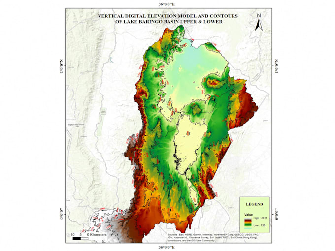
Ich bin ein GIS- & Fernerkundungsspezialist mit über 5 Jahren Erfahrung in der Bereitstellung hochwertiger geospatialer Lösungen für Umwelt-, Infrastruktur-, Versorgungs-, Naturschutz- und Entwicklungsprojekte in Kenia und darüber hinaus.
Was ich anbiete:
Tools, die ich verwende: QGIS, ArcGIS, ArcPro, Google Earth Engine, ILWIS, Python (geospatiale Automatisierung)
GIS Expert, Remote Sensing Specialist, Data Analyst, AI ML Specialist, Drone Pil
Sprachen
Automatische Übersetzung
Automatische Übersetzung
Welche Informationen muss ich angeben, um loszulegen?
Bitte teile mir dein Interessengebiet mit (Koordinaten, Shapefile oder Beschreibung), die Art der benötigten Karte/Analyse, bevorzugte Software (QGIS/ArcGIS) und alle vorhandenen Daten. Ich leite dich von dort aus!
Welche Dateiformate erhalte ich für die endgültigen Ergebnisse?
Du erhältst deine Karten als hochauflösende PNG/PDF für Druck oder Präsentation, sowie Shapefiles (.shp), GeoJSON oder Geodatenbank-Formate, je nach Bedarf.
Kannst du mit meinen bestehenden Daten oder Satellitenbildern arbeiten?
Ja! Ich kann mit deinen Shapefiles, Rasterdaten, GPS-Punkten, CSV-Koordinaten oder Satellitenbildern arbeiten. Bei Bedarf beziehe ich Daten auch aus Google Earth Engine, OpenStreetMap und anderen Plattformen.
Wie lange dauert ein typisches GIS-Mapping-Projekt?
Einfache Karten benötigen 1–2 Tage. Raum-Analysen oder Multi-Layer-Projekte dauern 3–5 Tage. Komplexe Geodatenbank- oder Fernerkundungsarbeiten können länger dauern. Zeitpläne bespreche ich immer im Voraus.
Bieten Sie Überarbeitungen an, wenn ich mit dem Ergebnis nicht zufrieden bin?
Absolut! Ich biete Überarbeitungen an, um sicherzustellen, dass die finale Karte deinen Erwartungen entspricht. Klare Kommunikation und Kundenzufriedenheit sind meine obersten Prioritäten.