Kategorien durchsuchen
Entdecken
Fiverr Pro
Deutsch
$
USD


Automatische Übersetzung
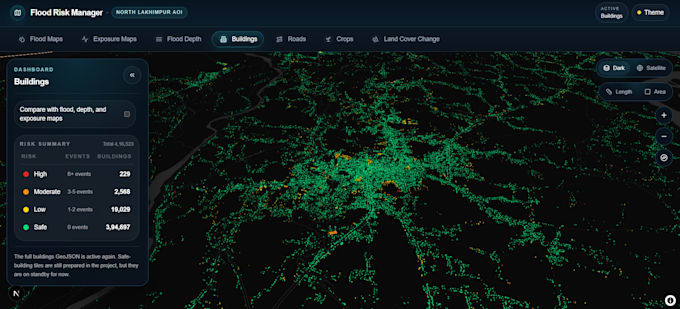
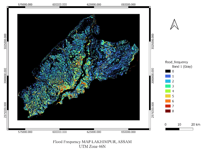
Ich biete professionelle GIS-, Fernerkundungs- und WebGIS-Dienste für Projekte an, die räumliche Datenverarbeitung, thematische Kartierung, Hochwasseranalyse, Landnutzung und Expositionsbewertung sowie interaktive geospatiale Dashboards umfassen. Meine Arbeit beinhaltet die Handhabung von Raster- und Vektordaten, die Organisation von Mehrschicht-Karteninterfaces und die Entwicklung webbasierter geospatiale Plattformen für Analyse und Visualisierung.
Ich unterstütze auch cloudbasierte geospatiale Workflows mit AWS, Docker, FastAPI, TiTiler, Next.js, MapLibre und deck.gl für skalierbare und einsatzbereite WebGIS-Lösungen.
MTech in Geospatial Engineering IIT Roorkee
Sprachen
Automatische Übersetzung
Automatische Übersetzung
Wie viele Jahre Erfahrung hast du mit geospatien Daten?
Ich habe über 4 Jahre praktische Erfahrung in der Arbeit mit geospatien Daten in GIS, Fernerkundung, Hochwasseranalyse, räumlicher Verarbeitung und WebGIS-Anwendungsentwicklung.
Bietest du Unterstützung beim Cloud-basierten Deployment an?
Ja, ich kann deployment-orientierte geospatiale Workflows mit AWS, Docker, FastAPI, TiTiler, GeoServer und modernen WebGIS-Stacks unterstützen.
Kannst du das Projekt an meine Anforderungen anpassen?
Ja, jedes Projekt kann individuell angepasst werden, basierend auf deinem Studiengebiet, Datenverfügbarkeit, Analysebedarf und gewünschten Outputs.
Was brauchst du von mir, um anzufangen?
Bitte teile dein Projektziel, Studiengebiet, verfügbare Daten, benötigte Outputs und bevorzugte Tools oder Formate mit.