Diese Dienstleistung ist vorübergehend nicht verfügbar

Ich werde Geodaten in ArcGIS und Python digitalisieren, analysieren, transformieren und visualisieren

B
bojanaobrenovic
B
bojanaobrenovic
Bojana
Einige Informationen wurden automatisch übersetzt.

Über diesen Service

Automatische Übersetzung

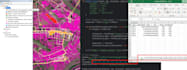
Ich biete die Möglichkeit, alphanumerische Daten aus verschiedenen Quellen (xlsx, txt, csv, Datenbankexporte) mit Raumdaten (Shapefile, KML, GeoJSON und mehr) zu verbinden und sie als passende Karte für Analysen, Präsentationen oder Berichte darzustellen

Lerne Bojana kennen

Bojana

Transforming spatial data with GIS tools and Python code

  • AusSerbien
  • Mitglied seitOkt. 2024
  • Sprachen

    Englisch
Geospatial Data Specialist | M.Sc. in Geodesy and Geoinformatics Engineering I am a dedicated Geospatial Data Specialist with a Master’s degree in Geodesy and Geoinformatics Engineering, specializing in geospatial data analysis and GIS development. With extensive experience in managing and analyzing diverse datasets, I bring a unique combination of technical expertise and analytical skills to deliver impactful, data-driven solutions.

Automatische Übersetzung

Verwandte Tags