Kategorien durchsuchen
Entdecken
Fiverr Pro
Deutsch
$
USD


Hi, thanks for checking out my gig.
I am a qualified Remote Sensing & GIS Analyst, combining technical expertise, GeoAI, and cutting-edge tools to deliver high-quality spatial solutions tailored to your needs.
What I Offer:
Tools & Technologies I Use:
Deliverables Youll Receive:
Available
Sprachen
What GIS or remote sensing software do you use?
I use ArcGIS Pro, QGIS, Google Earth Engine, and Python for accurate geospatial analysis.
Do I need to provide the satellite or drone data?
Not necessarily. I can access free satellite imagery or work with your provided data.
What formats will I receive?
You’ll get maps in PDF/PNG and geospatial files in SHP, KMZ, GeoTIFF, or your preferred format.
What kind of maps can you deliver?
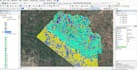
I deliver thematic, land use, NDVI, terrain, zoning, hydrology, and custom GIS maps based on your needs
How accurate is the analysis you provide?
I use high-quality data, proven methods, and expert tools to ensure reliable results.
Do you offer consulting before starting a project?
Yes, feel free to message me to discuss your goals before placing an order.
Can you handle large or complex geospatial projects?
Yes, I can manage both small and large-scale projects with professional accuracy.


