Kategorien durchsuchen
Entdecken
Fiverr Pro
Deutsch
$
USD

Level 2
Automatische Übersetzung
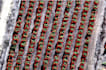
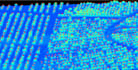
Brauchst du präzise Per-Baum-Kartierung und Analyse aus LiDAR-Daten?
Ich spezialisiere mich auf Einzelbaumkronen-Umriss (ITC), bei dem rohe LiDAR-Punktwolken in umsetzbare räumliche Daten für Forstwirtschaft, Landwirtschaft und Umweltprojekte umgewandelt werden.
Mit meinem Service erhältst du:
Einzelbaumkronen-Shapefiles (jeder Polygon steht für einen Baum).
Einzigartige Baum-IDs zur Verfolgung über mehrere Flüge oder Jahreszeiten hinweg.
Kronenfläche, Zentroid-Koordinaten und andere Attribute für jeden Baum.
Digitale Obst- oder Forstkarten für Management und Berichterstattung.
Anwendungen:
Lieferumfang:
Mapping Specialist
Level 2
Sprachen
Automatische Übersetzung
Automatische Übersetzung
Kannst du eine landwirtschaftliche Raumdatenbank für einzelne Bäume in meinem Obstgarten erstellen?
Ja, ich kann alle Attribute jedes Baumes erfassen und eine Überwachungsdatenbank erstellen
Was, wenn ich keine Lidar-Daten habe, kannst du Drohnenbilder verwenden?
Ja, ich kann Punktwolken aus den überlappenden Drohnenbildern nutzen
Kannst du die Waldbiomasse- und Ertragsabschätzung durchführen?
Ja, ich kann


