Kategorien durchsuchen
Entdecken
Fiverr Pro
Deutsch
$
USD


Automatische Übersetzung
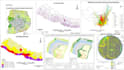
Hallo, ich bin Ashmita, eine Geomatikingenieurin, spezialisiert auf GIS, Fernerkundung und Kartografie. Ich führe professionelle GIS-Raumanalysen mit QGIS oder ArcGIS durch, inklusive Pufferanalyse, Überlagerungsanalyse, Dichtheitskartierung und Erstellung von thematischen Karten.
Leistungen umfassen:
Pufferanalyse
Überlagerungsanalyse
Punktdichtheitskarten
Proportionale Symbolkarten
Choroplethenkarten
Netzwerkanalyse (grundlegend)
Rasteranalyse
Karteninterpretation
Landnutzung und Landbedeckung
Überwachte und unüberwachte Klassifikation
Zusätzliche - Gefahrenkarten, Umweltüberwachungskarten
Geomatics Engineer
Sprachen
Automatische Übersetzung


