Kategorien durchsuchen
Entdecken
Fiverr Pro
Deutsch
$
USD


Automatische Übersetzung
Live-Demo:
https://wayanad-landslide-emergency-response.duckdns.org
Erstelle eine leistungsstarke und moderne WebGIS-Anwendung für Katastrophenmanagement, Umweltüberwachung, Infrastrukturplanung, Notfallreaktion, räumliche Analyse und interaktive Kartierung.
Ich spezialisiere mich auf die Entwicklung maßgeschneiderter GIS-Webanwendungen mit GeoServer, OpenLayers, QGIS, PostGIS, HTML, CSS, JavaScript und AWS-Deployment. Ich kann deine GIS-Daten in ein interaktives räumliches Dashboard mit professionellem UI/UX und Echtzeit-Karteninteraktion umwandeln.
Zu den Dienstleistungen gehören:
Interaktive WebGIS-Dashboards
GeoServer-Setup & Konfiguration
OpenLayers Web-Mapping
WMS/WFS-Integration
API-Integration
ETL- und Automatisierungs-Pipeline
Räumliche Analyse und Visualisierung
Katastrophen- & Notfallkarten
Routing- & Zugänglichkeitskarten
Individuelle GIS-Layer-Styling (SLD)
AWS-Deployment & SSL-Einrichtung
PostGIS-Integration
Unterstützte Formate:
Shapefile, GeoJSON, GeoPackage, Raster TIFF, PostGIS, WMS/WFS-Dienste und mehr.
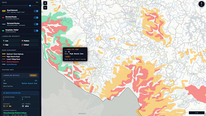
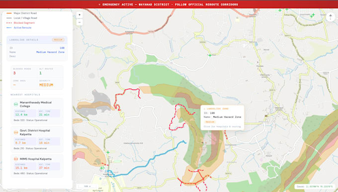
Vor Kurzem habe ich eine komplette Landslide Emergency Response WebGIS-Plattform entwickelt, die Landslide-Schweregrad-Kartierung, Zugänglichkeitsanalyse von Krankenhäusern, Blockaden-Erkennung, Umleitung-Visualisierung und interaktive Entscheidungsunterstützungstools umfasst.
GIS analyst and specialist
Sprachen
Automatische Übersetzung
Automatische Übersetzung
Welche Art von WebGIS-Anwendungen kannst du erstellen?
Ich kann Katastrophenmanagement-Dashboards, Umweltüberwachungssysteme, Notfallreaktionsplattformen, Infrastrukturkartierungsportale, Routing-Systeme, räumliche Analyse-Dashboards und maßgeschneiderte interaktive GIS-Webanwendungen erstellen.
Welche Technologien nutzen Sie?
Ich verwende hauptsächlich GeoServer, OpenLayers, QGIS, PostGIS, HTML, CSS, JavaScript, AWS EC2, Nginx und SLD-Styling für die GIS-Webentwicklung.
Kannst du die WebGIS-Anwendung online bereitstellen?
Ja. Ich kann dein Projekt auf AWS oder deinem bevorzugten Cloud-Server mit SSL/HTTPS-Konfiguration und Domain-Einrichtung bereitstellen.
Welche GIS-Datenformate unterstützt du?
Ich unterstütze Shapefiles, GeoJSON, GeoPackage, Raster TIFFs, CSV-Rauminformationen, PostGIS-Datenbanken, WMS/WFS-Dienste und viele andere GIS-Formate.
Wird die Anwendung auf Mobilgeräten funktionieren?
Ja. Ich kann responsive WebGIS-Dashboards erstellen, die mit Desktop-, Tablet- und Mobilgeräten kompatibel sind.