Kategorien durchsuchen
Entdecken
Fiverr Pro
Deutsch
$
USD

Gis Full Stack Developer
Kompetenzen
Meine Dienstleistungen

GIS / GEOAI DEVELOPER
INTERNATIONAL WATER MANAGEMENT INSTITUTE (IWMI) • Vollzeit
Oct 2024 - Present • 1 yr 8 mos
About IWMI: The International Water Management Institute (IWMI) is a global research organization focused on sustainable water management, climate resilience, groundwater governance, and irrigation modernization. IWMI leverages geospatial technologies, AI/ML, and data-driven systems to inform policy, improve agricultural productivity, and manage water resources efficiently. Responsibilities & Contributions: Led development of GIS dashboards for groundwater, irrigation, and flood monitoring, providing real-time spatial insights. Built GeoAI pipelines for land/water classification, flood detection, anomaly detection, and predictive modeling using VHR satellite imagery. Integrated WhatsApp Cloud API for automated geotagged alerts. Developed backend services with Flask and PostGIS, managed ETL workflows, and created responsive frontend components with Angular, Leaflet, and PrimeNG. Collaborated with domain experts to deliver scalable geospatial and AI-driven solutions
GIS FULL STACK WEB DEVELOPER
HEALTH INFORMATION & SERVICE DELIVERY UNIT (HISDU) • Vollzeit
Jan 2023 - Oct 2024 • 1 yr 9 mos
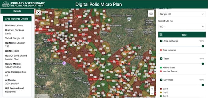
The Health Information & Service Delivery Unit (HISDU) is a Punjab Health Department initiative focused on digital transformation in healthcare. HISDU develops IT solutions to improve service delivery, vaccination campaigns, and operational monitoring using geospatial technologies for real-time insights and efficient decision-making. Led development of PolioWeb, a province-wide GIS dashboard for polio vaccination campaigns. Integrated GeoServer and QGIS for geospatial layers including administrative boundaries, health facilities, and vaccination routes. Developed modular frontend components using Angular + PrimeNG, enabling user management, menu navigation, map interactions, and dynamic filtering. Built backend APIs with Flask and PostgreSQL/PostGIS to serve spatial data and analytics. Collaborated with field engineers and policymakers to translate requirements into scalable GIS solutions. Trained HISDU staff on dashboard usage and operational monitoring workflows.
